Akhtala (Armenian: Ախթալա) (Persian and Urdu: آختالا) also Romanized as Akht’ala and Russified as Nizhnyaya Akhtala) a town in Lori Province, Armenia with 2800 inhabitants according to 2009 estimate. It is situated on the left bank of Debed river at a distance of 186 km north of Yerevan and 62 km north of provincial centre Vanadzor on the slopes of Lalvar mountain. Akhtala was a village until 1939 when it was granted the status of urban community. In 1995 the government of independent Armenia reaffirmed the status of Akhtala as a city.
During the 18th century, the village called Akhtala was part of Borchalu region of Tiflis governorate under the Russian rule. Starting from 1763 Greek experts from Gyumushkhane arrived in Akhtala by the request of King Erekle II of Georgia to exploit copper and silver mines and establish the copper and silver factory in Akhtala region. Therefore, the village was sometimes called "Peghendzahank" (copper mine) and "Artsatahank" (silver mine).

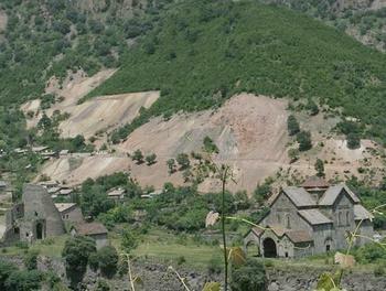
The old settlement of Akhtala is situated on the same territory of the mining site. Archeological excavations has shown that the area has been occupied by human since the early Bronze Age. The half-ruined fortress of Akhtala is more than 1000 years old. It was almost certainly built on top of Bronze and Iron Age foundations, in the late tenth century by the Kyurikids, this branch of the Bagratunis originated from Gurgen (the name was pronounced Kyurikeh in the local dialect of Gugark). He was the son of the patrons of Sanahin and Haghpat monasteries located not far from Akhtala, King Ashot III the Merciful and Queen Khosrovanush. Gurgen's brothers were King Smbat II the Conqueror and Gagik I Bagratuni, under whom the Bagratuni Kingdom of Armenia reached the peak of its prosperity.
Ashot III established the Kingdom of Lori (Tashir-Dzoraget Kingdom) in Gugark for strategic reasons and enthroned Gurgen in 982. Gurgen along with his brother Smbat are depicted on the sculptures of the patrons in both Sanahin and Haghpat. When the Tashir-Dzoraget kingdom fell as a result of Seljuk raids the Kyurikids migrated to Tavush and Metsnaberd yet they maintained ties with their ancestral fortress and compound in Akhtala. The impressive Akhtala monastery was reconstructed during the 13th century by prince Ivaneh Zakarian with a unique architectural style. This medieval Christian complex which is located inside the fortress has been one of the important educational centres in the historical Armenian province of Gugark.

Another significant architectural monument in Akhtala is the monastery of the Holy Trinity. During 1887-1889 excavations conducted by French archaeologist Jacques de Morgan, the site of a historical cemetery was unveiled with some bronze and iron objects, weapons, and ornaments dating back to the 8th century BC.
The settlement of modern Akhtala was known as Agarak in the 5th century. The main district of the modern town was previously known as Nerkin Akhtala. In 1970, Akhtala had 4430 inhabitants, while it was 2225 in the 2001 census
General information:
The climate of the town is subtropical with cool and dry summers and mild winters. Annual precipitation reaches up to 600 mm. The area is rich with copper, lead and silver mines which are of industrial importance and are being utilized.
The community has two public education schools, a house of culture, two libraries, a kindergarten, a sports ground, a hotel, a dispensary and a hospital. The town is home to the "Akhtala" Health Resort. Industry is the main specialized branch of the city.The main industrial enterprise of the town is the Akhtala Mining Plant which is owned by "Metal Prince" company. There are small manufactories as well for food productions.
The main problems of the community are related with the reconstruction of the historical monuments and the environment; mainly air and water pollution.
No comments:
Post a Comment