


 Dubalhati Rajbari, Naogaon, Bangladesh
Dubalhati Rajbari was originally the residence of the Maharajas of Dubalhati. About 53 Rajas and Jamindar(lanlords) ruled this place, governed from this palace. A feeder road through Deghoi Beel started from Naogaon Fisheries end, about 5.70 kilometers from Naogaon, provide the access to the palace area.
Raja Harendra Ray Chaudhury constructed the main fabric of this palace during the Pala Dynasty (750-1174). The architect of this palace is changed from time to time, is now a ruined place, standing tall as an evidence of monarch of that area. The palace has been destroyed by the Pakistani army during the war of independence in 1971. Present foundation is a rebuilt construction after the devastating jolt in 1897.
This palace blocks accommodated sleeping chambers, a Darbar(reception) hall, one dining hall, private theatre, prayer hall, guest house, stable and attendants quarter and a conference hall. Northern facing of the palace presents facades and long masonry columns vows the test of king and fondness Greek style architect. A plastered motif is still there, hanging on the internal entrance of palace. A turret is survived the destruction of weather. Few panel of terracotta is still there sticking on the wall. The palace was three storied building(first photo), now remain two floors left for further decay.
The entire palace area is surrounded by four ponds, in addition there are some six enormous tanks centering the palace. Most of these ponds were built for irrigation and supplying fresh water during the famine in 1874. There is a bazar (marketplace) in the vicinity of the palace. Probably archeology department has no budget for reconstruct this palace.


 |
| Kusumba Masjid, Naogaon, Bangladesh |

 | ||
| Kushumba Masjid, Naogaon, Bangladesh |
 Kusumba Masjid Naogaon, Bangladesh
Kusumba Mosque is named after the village of Kusumba, under the Manda upazila of Naogaon district, on the west bank of the Atrai river. It is inside a walled enclosure with a monumental gateway that has standing spaces for guards. It was built during the period of Afghan rule in Bengal under one of the last Suri rulers Ghiyasuddin Bahadur Shah, by one Sulaiman who was probably a high ranking official. The inscription tablet in Arabic (only the word 'built by' is in Persian) dating the building to 966 AH (1558-59 AD) is fixed over its eastern central entrance. Although built during Suri rule, it is not influenced at all by the earlier Suri architecture of North India, and is well grounded in the Bengal style. The brick building, gently curved cornice, and the engaged octagonal corner towers are typical features. The mosque, presently protected by the Department of Archaeology of Bangladesh, was badly damaged during the earthquake of 1897.
Although the main fabric of the building is of brick the entire exterior walls, and the interior up to the arches of the pendentives have stone facing. The columns, platform, floor, and perforated side screens are of stone. The mosque has a rectangular plan with three bays and two aisles, three entrances on the east and two each on the north and south sides (Fig. 2). The central mihrab is projected in the west. The interior west (qibla) wall has two mihrabs on the floor level opposite the central and southeastern entrances, but the one in the northwestern bay is above a raised platform ascended by a staircase on the east. The presence of such a platform in a non-imperial mosque indicates that not only royalty, but nobility and high-ranking officials were also separated from the general public during prayers.
The mihrabs have elaborate stone carving. They have cusped arches crowned with kalasa (water pot) motifs, supported on intricately carved stone pillars which have projections and tasseled decorations hanging from chains. Bunches of grapes and vines curve in an almost serpentine manner on the mihrab frames, and kalasas, tendrils and rosettes are reduced to dots. The platform edge has grape vine decoration, and there are rosettes on the spandrels of the arches supporting the platform, as well as on the mihrab wall.
The stone used in the exterior facing is of a coarse quality and carved in shallow relief. Mouldings are most prominent decorative feature on the outside. They divide the walls into upper and lower sections, run all along the curved cornice, around the corner towers, in a straight line below the cornice, and frame the rectangular panels in the east, south and north walls. The spandrels of the central entrance arch are filled with small kalasa and rosette motifs. The north and south sides have screened windows.


 Naogaon Govt. College
Naogaon Govt. College, is an educational institution in Naogaon District, Bangladesh which opened in 1962 with 300 students, and currently serves about 6000. Its 11-acre (45,000 m2) campus holds a 25000 book library and two three-story buildings, one of which is for science. The College runs Rover Scout, Bangladesh National Cadet Corp, and Internal Playspace extended programs.
Naogaon Govt. College was nationalized in 1980.


 Somupura Mahavihara, Paharpur, Naogaon, Bangladesh
Somapura Mahavihara (Sanskrit; Bengali: সোমপুর মহাবিহার Shompur Môhabihar) in Paharpur, Badalgachhi Upazila, Naogaon District, Bangladesh (25°1'51.83"N, 88°58'37.15"E) is among the best known Buddhist viharas in the Indian Subcontinent and is one of the most important archeological sites in the country. It was designated a UNESCO World Heritage Site in 1985.
A number of monasteries grew up during the Pāla period in ancient Bengal and Magadha. According to Tibetan sources, five great Mahaviharas stood out: Vikramashila, the premier university of the era; Nalanda, past its prime but still illustrious, Somapura Mahavihara, Odantapurā, and Jaggadala. The five monasteries formed a network; "all of them were under state supervision" and there existed "a system of co-ordination among them . . it seems from the evidence that the different seats of Buddhist learning that functioned in eastern India under the Pāla were regarded together as forming a network, an interlinked group of institutions," and it was common for great scholars to move easily from position to position among them.
The excavation at Paharpur, and the finding of seals bearing the inscription Shri-Somapure-Shri-Dharmapaladeva-Mahavihariyarya-bhiksu-sangghasya, has identified the Somapura Mahavihara as built by the second Pala king Dharmapala (circa 781-821) of Pāla Dynasty.. Tibetan sources, including Tibetan translations of Dharmakayavidhi and Madhyamaka Ratnapradipa, Taranatha's history and Pag-Sam-Jon-Zang, mention that Dharmapala's successor Devapala (circa 810—850) built it after his conquest of Varendra. The Paharpur pillar inscription bears the mention of 5th regnal year of Devapala's successor Mahendrapala (circa 850—854) along with the name of Bhiksu Ajayagarbha. Taranatha's Pag Sam Jon Zang records that the monastery was repaired during the reign of Mahipala (circa 995—1043 AD).
The Nalanda inscription of Vipulashrimitra records that the monastery was destroyed by fire, which also killed Vipulashrimitra's ancestor Karunashrimitra, during a conquest by the Vanga army in the 11th century, assumed to be an army of the Varman rulers. About a century later Vipulashrimitra renovated the vihara and added a temple of Tara.
Over time Atish's spiritual preceptor, Ratnakara Shanti served as a sthavira of the vihara, Mahapanditacharya Bodhibhadra served as a resident monk, and other scholars spent part of their lives at the monastery, including Kalamahapada, Viryendra and Karunashrimitra. Many Tibetan monks visited the Somapura between 9th and 12th centuries.
During the rule of the Sena dynasty, known as Karnatadeshatagata Brahmaksatriya, in the second half of the 12th century the vihara started to decline for the last time. One scholar writes, "The ruins of the temple and monasteries at Pāhāpur do not bear any evident marks of large-scale destruction. The downfall of the establishment, by desertion or destruction, must have been sometime in the midst of the widespread unrest and displacement of population consequent on the Muslim invasion."
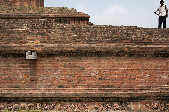
The quadrangular structure consists of 177 cells and a traditional Buddhist stupa in the center. The rooms were used by the monks for accommodation and meditation. In addition to the large number of stupas and shrines of various sizes and shapes, terracotta plaques, stone sculptures, inscriptions, coins, ceramics etc. have been discovered.
The site houses the architectural remains of a vast Buddhist monastery, Somapura Mahavihara, covering 27 acres (110,000 m2). It was an important intellectual centre for Dharmic Traditions such as Buddhists (Buddha Dharma), Jains (Jaina Dharma) and Hindus (Sanatana Dharma) alike. The 21 acre (85,000 m²) complex has 177 cells, viharas, numerous stupas, temples and a number of other ancillary buildings. The outside walls with ornamental terracotta palques still display the influence of these three religions.
In terms of acreage, Somapura was the largest of the mahaviharas. It was also quite unusual architecturally. As one scholar described, the complex was dominated by a temple, which was not typical, and further, the temple had "none of the characteristic features of Indian temple architecture, but is strongly reminiscent of Buddhist temples of Burma, Java and Cambodia, reproducing the cruciform basement, terraced structure with inset chambers and gradually dwindling pyramid form . . during the age of the Palas some sort of intercourse between eastern India and south-east Asia existed . . but how this temple type, represented in India by this solitary example, became the standard of Buddhist temple architecture is not known." Another commented, "there can be no doubt that this style of architecture has most profoundly influenced that of Burma, Java and Cambodia. The nearest approximation to the plan and the superstructure of the Paharpur temple is afforded by the temples known as Chandi Loro Jongrang and Chandi Sevu of Prambanam in Central Java."
The purpose of this central structure at the midst of the courtyard remains unsolved since its discovery. Hence most of the debates generated hitherto on the architecture of Sompur Mahavihara are cantered on the identification its missing superstructure. The reason may be manifold, but the most important one is the non-availability of substantial amount of first hand resource including a comprehensive architectural documentation at the disposal of the researchers. There are different arguments regarding the terminating top of the central structure of Sompur Mahavihara.
Consequently, most of works done so far are mainly based on the findings of the archaeological excavation and studying the artefacts from the archaeological perspective. The first ever study on this monument with documentation was been carried by archaeologist K.N. Dikhist in his, Paharpur, Memoirs of Archaeological Survey in India (1938). Dikhsit was not only concerned with documentation of the archaeological findings, but also concentrates on their interpretation and analysis. He also made an attempt to suggest a probable architectural treatment of the missing parts of the structure through studying the archaeological remains. Till today, this study is considered as the most authentic record of the Sompur Mahavihara.
Prudence R. Myer published the first of such studies in 1969 as a journal paper, in which he proposed the missing superstructure as a stupa and illustrated the possible three-dimensional articulations. Myer embarked on his proposal through a diachronic study of the Stupa and Stupa shrines in India. He took Sompur Mahavihara as an example to elaborate his study and did a conjectural restoration of the central structure in support of his analysis.
The second work was published around thirty years after Myer's proposition. A team of architects from Khulna University lead by Mohammed Ali Naqi has proposed another theoretical reconstruction of the central structure as well as some parts of the peripheral block (mainly the entrance hall) in 1999. This work was also presented in the "International Seminar on Elaboration of an Archaeological Research Strategy for Paharpur World Heritage Site and Its Environment" jointly organized by UNESCO and Department of Archaeology of Bangladesh in 2004. Muhammad Ali Naqi proposed a temple-like spire at the top by considering the central mound as a ‘Stupa-Shrine’ with a ‘Shikhara’ type stupa in his reconstruction.
Somapura was designated a UNESCO World Heritage Site in 1985. Since then, a series of UNESCO missions has regularly visited the site and helped with the project. Moreover, the UN body also prepared a master plan, involving 5.6 million dollars.
The various terracotta artworks within the site have suffered from serious damage as a result of "lack of proper maintenance, shortage of manpower, fund constraint and heavy rainfall." Furthermore, poor water drainage in the site accompanied by high levels of salinity in the soils has also contributed to decay the terracotta sculptures. Other threats include uncontrolled vegetation, vandalism, climatic conditions, and public trespassing and encroachment.
Sompur Bihar at Paharpur is about 282 ;km by road from Dhaka and it will take about 6.5 hours to reach Paharpur by bus/taxi/private car if no major stops are made along the way. If one starts from Dhaka, the route shall be Dhaka - Savar - Chandra - Tangail - Jamuna Bridge - Bogura - Joypurhat - Paharpur. The best way to tour the site is to first reach Naogaon and stay there in hotel or reach Badalgacchi and stay there in Dakbanglo.


.jpg)


No comments:
Post a Comment